
Tropical Storm Sandy is continuing to move toward Jamaica, strengthening as it goes. It will probably become a hurricane tomorrow. But it’s the longer-term forecast for Sandy that has meteorologists running around like their hair is on fire. Words like “historic,” “extraordinary” and “unprecedented” are being used to describe what might occur along the U.S. East Coast.
Since my previous post earlier Tuesday, it now appears more likely that Sandy will stay somewhere near shore — “trapped” by a blocking ridge of high pressure — rather than recurving harmlessly out to sea. It will then encounter an unusual, jet-stream-fueled clash between very warm and very cold air. While the details are impossible to forecast with precision this far out, these dynamics could produce a highly unusual situation in which a partially tropical, partially non-tropical cyclone could see its barometric pressure drop into the range of a major hurricane. That storm could track toward New England from the southeast, an unusual and dangerous track.
If the worst-case scenario occurs — and at this point, it’s still just that, a scenario — Sandy could have devastating effects on the U.S. East Coast next week. I’ve seen comparisons being thrown around to the Perfect Storm of 1991, Hurricane Hazel of 1954, and even the Long Island Express of 1938. I say that not to alarm folks with the specifics of any particular comparison — after all, the details are very much in doubt at this point — but simply to give a sense of how seriously meteorologists are taking this threat and its potentially historic nature.
The Weather Channel’s hurricane specialist, Bryan Norcross, summarizes the thinking on what will happen with Tropical Storm Sandy:
Wow… what an extraordinarily unusual scenario. What seemed like a fluke of an idea – a hurricane-like system hitting the northeastern U.S. – is gaining credibility. Originally the European model was on its own with the spectacular but somewhat bizarre idea that Sandy would be injected with jet stream energy and curve back toward New England as a stunningly strong storm. Now one model after the other, including the [GFS] ensembles, are favoring a swing back toward the East Coast after the storm goes by Cape Hatteras. … The majority of the possible tracks now head into the Northeast, New England, or Atlantic Canada.
Could it really be a strong hurricane, as the European model predicts? We know that, occasionally, hurricanes do occur at these high latitudes at the end of October. Famously, the “Perfect Storm”, otherwise known as the Halloween Hurricane battered New England in 1991. Also, Category 2 Hurricane Ginny hit Nova Scotia in late October 1963. But, neither were of a scale and impact like the Euro is showing.
With the influence of the jet stream, you would think any storm that comes ashore would be subtropical in nature – part tropical and part like a nor’easter – but the NHC doesn’t allow for subtropical hurricanes in their naming scheme. It’s considered to be such a rare and nearly impossible event.
The spectacularly unusual confluence of events is the shape and orientation of the dip in the jet stream that is forecast to develop over eastern North America over the weekend – oriented in such a way to pull Sandy inland instead of pushing it out to sea, and the presence of a strong tropical or subtropical system where it can get pulled in. That’s so bizarrely unusual that I can’t think of another event like it.
This kind of thing occasionally happens with nor’easters, notably the Great Appalachian Storm of November 1950 which curved in off the Atlantic and dumped 20 to 30 inches of snow over a wide area in the Mid-Atlantic and Midwest, but the odds of it happening with a system that originated in the tropics – with all of the moisture that that implies – are extremely low.
We certainly don’t know that it’s going to happen…[but] with more models leaning that way, we need to be aware and pay attention along the entire U.S. East Coast.
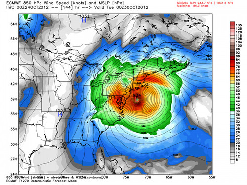
That post was written a few hours ago, and if anything, the model outlook has since gotten worse since then. Over at Weather Bell Premium, Joe Bastardi points to the latest Euro model run (below) and writes: “This would be a devastating storm on our mid and north Atlantic coast, the ultimate track for NYC and Long Island, with crushing snows in the mountains of western Pennsylvania and West Virginia. … The ECMWF emphatically says this…will lash the coast from the Carolinas to New England with hurricane conditions.”
Yikes. More tomorrow. Stay tuned.


Join the conversation as a VIP Member