
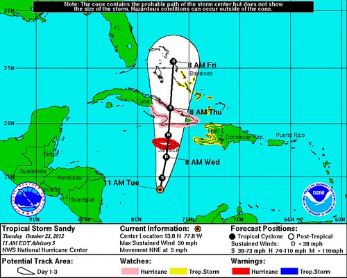
Tropical Storm Sandy has formed in the Caribbean, and is steadily intensifying as it moves north toward Jamaica. Sandy is forecast to become a hurricane before hitting that island tomorrow, and Hurricane Warnings have been issued Jamaica, and Hurricane Watches for Cuba:
How strong will Sandy get, and when? Dr. Jeff Masters explains the intensity forecast timeline:
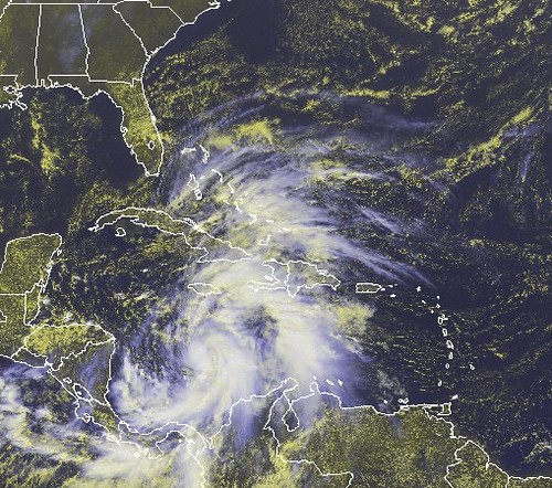
Sandy is over very warm waters of 29.5°C, is in an unusually moist environment with relative humidities above 80%, and is experiencing light wind shear of 5 – 10 knots. These conditions are very favorable for intensification, and Sandy’s heavy thunderstorms have increased in areal extent, intensity, and organization this morning, as seen on satellite loops. …
Wind shear is forecast to be in the low to moderate range, 5 – 20 knots, through Thursday morning. This should allow continued development of Sandy, and rapid development is possible. The 8 am EDT SHIPS model forecast predicted a 62% chance that Sandy’s winds would increase by 30 mph over a 24-hour period. However, the Hurricane Hunters found this morning that the center at 5,000 feet was displaced 7 miles from the surface center, and there was no indication that Sandy was building an eyewall, so I expect that the earliest Sandy could become a hurricane is Wednesday morning. The 5 am EDT NHC Wind Probability Forecast gave a 49% chance that Sandy would be a hurricane by 2 pm EDT Wednesday, when the center should be close to Jamaica. Wind shear will rise to a high 25 – 30 knots by Thursday and the storm will have to cross the rugged terrain of Cuba, which should weaken Sandy’s winds by 20 – 30 mph. By Friday, Sandy should be over warm waters in the Central Bahamas, but only modest re-intensification by 10 – 20 mph should occur, due to high wind shear.
Officially, Sandy’s winds are forecast to peak at 80 mph before hitting Cuba. Here’s what the storm looks like right now:
What about potential U.S. impacts? That’s where the story gets complex. There is a very realistic chance that Sandy could recurve harmlessly out to sea — a “fish” storm, at least from the U.S. perspective. However, there are also less favorable possibilities:
It’s unclear now how threatening Sandy will be come Friday, because its path depends on several weather factors, but there is potential for a “tropical nightmare,” AccuWeather.com reports.
The storm could ruin some weekend plans for East Coast residents from Florida to the Carolinas, before being drawn inland to the mid-Atlantic or New England states early next week. While the Southeast coast might be dealing with heavy rains, forceful winds and rough surf, areas from Virginia to Maine could be at even greater risk. In the worst-case scenario, the storm could pack high winds and dump rain, possibly causing widespread flooding and a significant storm surge northeast of its center.
AccuWeather.com says this impending weather is “reminiscent of the Perfect Storm,” and could even create heavy snow in the Appalachian Mountains, on the future storm’s western side.
Dr. Masters explains:
[By Friday,] a very complicated meteorological situation unfolds, as Sandy interacts with a trough of low pressure approaching the U.S. East Coast. The trough may steer Sandy northeastwards, out to sea, as predicted by the GFS, HWRF, and GFDL models. However, an alternative solution, shown by the ECMWF and NOGAPS models, is for the trough to inject a large amount of energy into Sandy, converting it to a powerful subtropical storm that hits New England early next week with a central pressure of 948 mb and winds near hurricane-force.
Take a look at Weather Underground’s GFS ensemble models map to get a sense of the wide range of possible tracks:
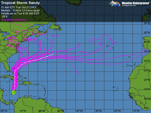
(Here’s how Masters captions that image: “The Tuesday morning 06Z (2 am EDT) run of the GFS model was done 20 times at lower resolution with slightly varying initial conditions of temperature, pressure, and moisture to generate an ensemble of forecast tracks for Sandy (pink lines). These forecasts show substantial uncertainty in Sandy’s path after Friday, with the majority of the forecasts taking Sandy to the northeast, out to sea, but a substantial number predicting a landfall in the Northeast or mid-Atlantic states of the U.S. The white line shows the official GFS forecast, run at higher resolution.”)
Lest I be accused of unjustified “hype,” it’s important to be very clear that Sandy may very well amount to nothing for the United States. It’s simply too early to tell. Dr. Ryan Maue believes the forecast will remain low confidence until after Sandy crosses Cuba and enters the Bahamas. So we have 48+ hours to watch and wait. Then things should begin to become more clear. Meanwhile, there is no reason to #PANIC about another “perfect storm” — nor even to adjust your plans for the weekend or early next week (like, say, plans for campaigning in New Hampshire) just yet. But Sandy definitely bears watching, so keep an eye on the forecast.
P.S. Wondering about the timing? Masters: “The ECMWF and NOGAPS models are off by a full day in their predictions of when the storm would arrive, with the 06Z NOGAPS model predicting Sandy’s heavy rains will arrive on North Carolina’s Outer Banks on Sunday, then spread into the mid-Atlantic and New England on Sunday. The 00Z ECMWF model forecast predicts that Sandy will arrive in New England on Monday night. Stay tuned.” As they say.


Join the conversation as a VIP Member