
[NOTE: For the very latest on Irene, check my Twitter feed.]
* * * * *
As I’ve said repeatedly, the big storyline with regard to Hurricane Irene’s coastal impact isn’t the winds, but the storm surge. Even if Irene weakens to a tropical storm overnight, as she may, what we really need to watch is how high the surge gets. Of particular significance, New York’s subway system will reportedly flood if the storm surge is more than 3 to 4 feet above the already astronomically high tide tomorrow morning.
With that said, check out this NOAA chart, updating in real time (or close to it), of the water level at The Battery in Lower Manhattan:
Click on the chart for a larger version. The blue line is the expected, “normal” water level, as the tides come in and out. Actually, “normal” isn’t quite right, since we’re dealing with astronomically high tides, thanks to the New Moon. But anyway, the blue line is what the tides would be without Irene.
The red line is the actual water level. When you see the red line not declining, or only declining slightly, while the blue line is going way down, that’s bad news. It means the storm surge is preventing the tide from going out, so the next high tide will likely be much higher (assuming the surge is still present when the tide comes in).
But the one to really watch is the green line. This is the “residual” level, the difference between the red and blue lines. Basically, the green line is the storm surge. So, for instance, if the red line is declining as the tide goes out, but not as much as it “should” be declining (as in the scenario just discussed), that will cause the green line to go up.
Low tide is at 2:14 AM. High tide is at 8:07 AM. Irene’s expected closest pass is expected at around 8:00 10:00 AM — so it’ll be very nearby at high tide. Awful timing. (Once the storm passes, the winds shift to blowing offshore, and the storm surge begins to fall away. See, for instance, Yorktown, VA. But in NYC, that likely will not happen until after high tide.)
Oh, and wave heights, I should note, are on top of the surge.
Regarding the subway, if you want to get a little more into the weeds… based on what Dr. Jeff Masters has written about this, it appears the seawall that protects the subway is approximately 8 feet above the “MLLW,” or “Mean Lower Low Water” level. An average high tide is roughly 4.5 feet above MLLW. The New Moon adds another 0.5 feet to tomorrow’s high tide. That leaves a 3-foot margin for error, give or take a few inches. So a surge of greater than 3 feet at high tide would likely flood the subway, unless Dr. Masters is wrong or I’m missing something here.
Moreover, if the surge reaches 4.5 feet at high tide, here are some of the areas that would potentially be underwater at high tide, according to Climate Central:
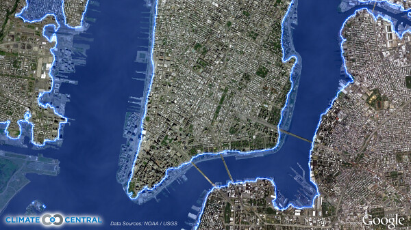
Note: I’m not sure if that map takes into account seawalls and such. So take it with a grain of salt, giving you a general idea of the amount of territory at risk, but not necessarily a precise block-by-block map of who’d be flooded.
The Weather Channel’s Bryan Norcross just broached the possibility of a 7- or 8-foot surge. I have no idea what that would do, beyond a vague assumption that it would be very bad. It seems high to me — but then again, New York harbor is acting like a giant funnel, so maybe it could happen. Hopefully not.
* * * * *
Anyway, that’s the situation with New York City. But of course, Gotham isn’t the only place at risk. And I thought it might be helpful to try and collect all the relevant tidal information in one place. NOAA maintains an excellent site where you can view tidal gauges for a variety of locales all around the country, including up and down the East Coast, but they’re all on individual pages. It also has a great “QuickLook” page where you can view this data, and more, about Hurricane Irene. But for viewing the critical storm surge data, and only that data, all in one place, I’m taking the liberty of combining a bunch of these charts in this post, on the next page.
One big caveat to all of this: I’m not a meteorologist, but I at least know a fair bit about meteorology from a layman’s perspective. Hydrology is a different story. I am definitely not a hydrologist, and I can’t even pretend to play one on the Internet. So while I think I’m getting the basic facts right here, it’s possible I’m making some mistakes in interpreting these charts. If someone more knowledgeable than I sees an error, please let me know!
Anyway, on with the tidal gauges:
Ocean City, Maryland
Low tide: 1:27 AM
High tide: 7:42 AM
Irene’s expected closest pass: ~12:00 AM
Lewes, DE (south side, mouth of Delaware Bay)
Low tide: 2:16 AM
High tide: 8:29 AM
Irene’s expected closest pass: ~1:00 AM
Delaware City, DE (well inside Delaware Bay)
Low tide: 5:47 AM
High tide: 11:11 AM
Irene’s expected closest pass: ~1:00 AM
Cape May, NJ (north side, mouth of Delaware Bay)
Low tide: 2:10 AM
High tide: 8:22 AM
Irene’s expected closest pass: ~3:30 AM
Atlantic City, NJ
Low tide: 1:12 AM
High tide: 7:17 AM
Irene’s expected closest pass: ~6:00 AM
Sandy Hook, NJ (mouth of New York Harbor)
Low tide: 1:44 AM
High tide: 7:41 AM
Irene’s expected closest pass: ~9:00 AM
Bergen Point, NY (north shore of Staten Island)
Low tide: 2:26 AM
High tide: 8:10 AM
Irene’s expected closest pass: ~10:00 AM
The Battery, NY (Lower Manhattan)
Low tide: 2:14 AM
High tide: 8:07 AM
Irene’s expected closest pass: ~10:00 AM
Kings Point, NY (north shore of western Long Island)
Low tide: 5:23 AM
High tide: 11:03 AM
Irene’s expected closest pass: ~10:00 AM
Bridgeport, CT (on Long Island Sound)
Low tide: 5:04 AM
High tide: 11:10 AM
Irene’s expected closest pass: ~11:00 AM
New Haven, CT (on Long Island Sound)
Low tide: 4:55 AM
High tide: 11:05 AM
Irene’s expected closest pass: ~11:00 AM
New London, CT (on Long Island Sound)
Low tide: 3:23 AM
High tide: 9:09 AM
Irene’s expected closest pass: ~11:00 AM
Montauk, NY (north side, facing Long Island Sound)
Low tide: 3:01 AM
High tide: 8:43 AM
Irene’s expected closest pass: ~11:00 AM
Newport, RI
Low tide: 1:14 AM
High tide: 7:36 AM
Irene’s expected closest pass: ~11:00 AM
Woods Hole, MA
Low tide: 2:45 AM
High tide: 7:56 AM
Irene’s expected closest pass: ~11:00 AM
UPDATE: Irene Makes Landfall in NYC


Join the conversation as a VIP Member