
With the caveat that you should never put too much stock in any single computer model run… it appears that the GFS model’s rightward “trend” has halted, at least for the moment, and even slightly reversed. The much-anticipated 12Z run shows basically the same closest pass to North Carolina as the 6Z run, and an ever-so-slightly further west landfall point in Southern New England.
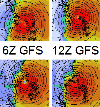
(Graphic created by me, via MeteoStar.)
Perhaps Glenn Reynolds is right about Martha’s Vineyard, and the models have stopped trending east now that they’ve got President Obama in their sights. Heh. (Hey wait, those isobars look kind of like a target! #OldTone! I blame Palin!)
Meanwhile, I’m told (though I haven’t seen it) that the NOGAPS model has shifted from one of the furthest east models to one of the furthest west. The 12Z European model isn’t out yet; it’ll be important to see what that one looks like. Further down the road, I’m told that tonight’s 0Z runs (due out between 11:30 PM and midnight Eastern time) will incorporate some new data from the trough of low pressure currently over Alaska* that figures to be a major player in the steering of Irene, so those model runs will be important to watch.
Bottom line, the Outer Banks of North Carolina and the New York/New Jersey/New England area are still very much under threat. I had thought that the threat might start to alleviate today; that now appears less likely, and indeed perhaps the opposite is happening. But, as always, stay tuned.
*Another reason to blame Palin, obviously.


Join the conversation as a VIP Member