
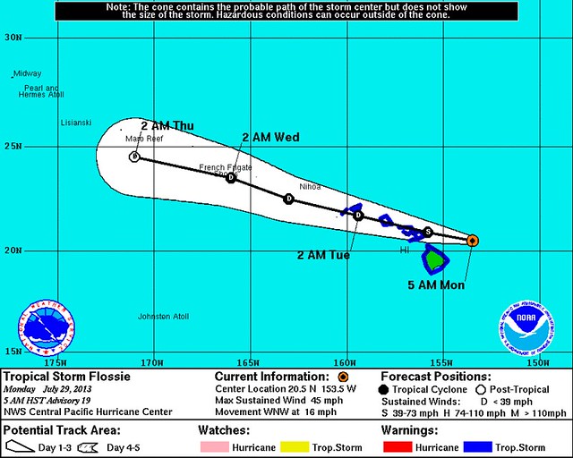
There’s been a significant change overnight to Tropical Storm Flossie’s expected path as it moves into Hawaii today. Last night, the forecast called for a direct hit on the Big Island late this morning or around noon Hawaii Time (6pm Eastern) today. Not anymore:
The Central Pacific Hurricane Center (CPHC) explains:
THE CENTER OF FLOSSIE WAS HIDDEN BY HIGH CLOUDS MOST OF THE NIGHT BEFORE VIRS NIGHTTIME VISUAL SATELLITE IMAGERY REVEALED AN EXPOSED LOW LEVEL CIRCULATION CENTER FARTHER NORTH THAN EXPECTED. WE RE-BESTED THE 0600 UTC POSITION BASED ON THE VISIBLE DATA. … THE TRACK HAS BEEN SHIFTED NORTH TO REFLECT THE RE-LOCATED CENTER. THE TRACK GUIDANCE SHIFTED FOLLOWING THE TRACK CHANGE AND WAS CONSISTENT WITH A NEW TRACK FARTHER TO THE NORTH. THE TRACK NOW SHOWS FLOSSIE PASSING OVER MAUI TODAY…OVER OAHU TONIGHT…THEN PASSING SOUTH OF KAUAI EARLY TUESDAY MORNING.
An aside: “VIRS nighttime visual satellite imagery” is a new one for me. Here’s an explanation. (Hat tip: Ryan Maue.)
Anyway, I guess we’ll never know whether, had it continued on its expected course, Flossie would actually have managed to hit its tiny, mountainous target of the Big Island, or whether it would have instead “bounced” or “wobbled” away, due to the split flow effects of those high mountains. (Or maybe we do know? Did the storm’s western circulation hitting the Big Island help cause the center’s relocation to the north? Honestly, I have no idea. Maybe Flossie “bounced” away in fear of Jim Cantore… heh.)
Regardless, maybe the biggest impact of this change is that it delays Flossie’s initial landfall (now expected in Maui) by several hours, to perhaps somewhere in the range of 2-4pm local time (8-10pm Eastern). That’s significant because the storm appears to be rapidly falling apart:

Again quoting the CPHC:
SATELLITE LOOPS SUGGEST A RAPID WEAKENING TREND WITH THE LOW LEVEL CENTER PULLING AWAY FROM A SMALL AREA OF CONVECTION SOUTHEAST OF THE CENTER. IT IS LIKELY THAT CONTINUED NORTHWEST SHEAR WILL MAINTAIN THIS WEAKENING TREND. WE EXPECT FLOSSIE TO WEAKEN STEADILY AS IT TRACKS WEST NORTHWEST AND DISSPATE WITHIN 96 HOURS.
So much for that next SyFy Original Movie…
Hey @SyFy … #Flossie nearing Big Island … can you say #VOLCANICANE?!? Storm-spawned tornadoes send lava-breathing sharks into Honolulu!!! ;)
— Brendan Loy (@brendanloy) July 29, 2013
Heh. Sorry, I couldn’t resist.
On a more serious note, it’s important to remember that tropical storms are not a “point.” Flossie will still impact the Big Island, even though its center of low-level circulation will “miss.” Information on timing of tropical storm conditions:
"Tropical Storm conditions expected to reach Big Island this AM, Maui by late AM, Oahu this eve & Kauai later tonight." -CPHC #Flossie #hiwx
— Robert Ballard (@firebomb56) July 29, 2013
The Honolulu office of the National Weather Service has more information, including:
Most likely impacts to the Hawaiian islands include heavy rain, dangerous surf conditions along east facing shores, damaging winds and possible flash flooding. Rock and mudslides caused by heavy rain will be possible, especially in steep terrain. Pounding surf will rise rapidly along the east and southeast coasts of the Big Island and Maui, with surf peaking today, with coastal flooding possible. Surf heights along east facing shores will be between 10 and 20 feet. Isolated tornadoes and waterspouts will be possible with tropical storm Flossie, mainly over Maui county and the Big Island.
More info in the Flash Flood Watch bulletin. Speaking of which, Mike Smith notes a silver lining: “While there will be flooding, much of the State of Hawaii has been in a drought, so the storm may be a net plus.” He added later: “These heavy rains will end a drought.”
Meanwhile, back on the Atlantic side, Zombiewave Dorian continues to flirt with resurrection:
#Dorian looking quite healthy this morning. If thunderstorms persist & a closed-low, then back to TD/TS pic.twitter.com/wVzNE2dohV
— Ryan Maue (@RyanMaue) July 29, 2013
Mark Sudduth isn’t so sure:
The remnants of Dorian, labeled as 91L, are flaring up again today with quite a bit of deep convection noted in satellite imagery. However, surface pressures in the area are very high, near 1015-1016 mb and are not falling apparently. I think what we have is a vigorous tropical wave with perhaps a mid-level circulation. While it’s possible for the system to make enough of a comeback to be designated a tropical storm again, I think the odds are against it. Upper level winds are not going to let up enough and the background pressures are just too high.
With that being said, the wave of low pressure will bring showers and gusty winds to portions of the southern Bahamas, Cuba and south Florida over the next few days.
We’ll see. The computer models aren’t sure what to make of the Zombiewave:
And here's the latest 12z intensity plots for the remnants of #Dorian. Kinda all over the place, right? pic.twitter.com/yntUsjdxMM
— Eric Burris (@ericburris) July 29, 2013
Stay tuned. As per usual: I’m on Twitter at @brendanloy, and even more frequent updates by others on Twitter can be found easily via Amy Sweezey’s “Wx Tweeps” list.


Join the conversation as a VIP Member