
[NOTE: For my latest updates on Hurricane Sandy, follow me on Twitter.]
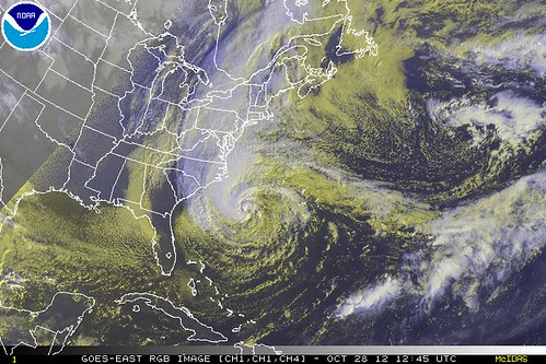
Hurricane Sandy’s barometric pressure dropped from 960 millibars at 5am EDT to 951mb at 8am, and new convection is appearing around the center. The lessening of wind shear, and the influence of the warm Gulf Stream waters underneath Sandy, are having the expected effect: deepening of the low pressure at the storm’s core. Meanwhile, the wind field continues to expand, to historic proportions. Sandy is now the largest hurricane in Atlantic history, with its tropical storm-force winds having a diameter of more than 1,000 miles!
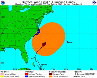
The computer models continue to forecast this storm remarkably well, particularly given its uniqueness and complexity, and there’s really no reason at this point to doubt the remainder of their prediction: Sandy will keep getting better organized today, will “bomb out” tomorrow — not long before landfall — into a monster storm with possibly record-low pressures for the Northeast/mid-Atlantic, will hang a sharp left turn into New Jersey, and will bring a huge, devastating, life-threatening, wind-driven storm surge (worsened by extremely high surf and astronomical high tide) into Long Island Sound, New York Harbor, the south shore of Long Island and the Jersey Shore. Coastal damage will be extensive. Wind damage will also be severe, including well inland, due to the sustained battering and the possibility of unusually extreme gusts due to PV towers and tropopause folds. Property losses will be extraordinary. Loss of life is probable if people do not take this storm very, very seriously.
After making landfall, Sandy will finish its transition to an extratropical (but still-powerful) storm, and will dump heavy snow on portions of West Virginia and Pennsylvania. Elsewhere, it will dump heavy rain, producing inland flooding in some areas (though it probably will not be as bad as the devastating inland floods from Irene, because the ground is less saturated). Millions will lose power, many through Election Day and beyond.
If you’re in an impacted region, today is your last day to prepare. By tonight, weather conditions will already be deteriorating. So, as the weather service always says at times like these, “Preparations to protect life and property should be rushed to completion.” (Preparedness links can be found at the bottom of this post.)
If you’re in a surge-vulnerable coastal area, you may need to leave. Listen to what local officials say about whether you should evacuate — unless you live in New York City, in which case you should ignore your foolish mayor and, if you live in Zone A or Zone B and are vulnerable to a possible surge of up to 10 feet, GET THE HELL OUT! (Criticism of Bloomberg’s bizarre, inaccurate press conference yesterday is damn near universal in the meteorological community. I’ve never seen anything like it.) Wherever you are, DO NOT STAY PUT, IGNORING EVACUATION ORDERS, SIMPLY BECAUSE YOUR HOME WAS FINE IN SOME PREVIOUS STORM. Every storm is different, and this storm will be historically bad in many places. If you’re ordered to leave — leave. If it’s even suggested by your local officials that you leave — leave. Do not risk it. It’s not worth it.
Beyond that, it’s difficult to think of new things to say about Sandy. Assuming the computer models — so accurate to this point — aren’t totally out to lunch, we basically know what the storm is going to do, and where its center will go (with the computer model forecast “envelope” now being essentially from South Jersey to North Jersey), and what its impacts will be. We’re now pretty much just waiting for it all to happen. The board is set; the pieces are moving.
Connecticut meteorologist Geoff Fox writes:
Hurricane Sandy is less than two days away. It is a major threat to our state. Don’t think that kind of weather doesn’t happen here, because it does and there’s every indication it will!
I am fearful. I suspect fear is now a common emotion in Connecticut. It is warranted.
What struck me today is how few surprises there were. Considering Hurricane Sandy has a structure like no other storm we’ve seen and is taking a path unlike any I’ve experienced, the computer guidance has been amazingly consistent.
Consistent model agreement implies the computers have properly latched onto Sandy’s salient features.
What’s come into sharper focus is the potential for shoreline flooding. If the guidance is right this will be a coastal inundation of historic proportions. The damage and destruction will be the most seen since the Hurricane of ’38, maybe more! …
Stay safe. Protect your family. Protect yourself. Be smart.
UPDATE: Bloomberg has ordered a Zone A evacuation in NYC, thank goodness. I’m still a bit concerned about Zone B, or at least parts of it. The water level at Battery Park is currently forecast to exceed 11 feet at its peak. That would break records.
More this evening. I intend to do a live tidal gauge / radar / satellite / wind gauge / etc. post, like I did with Irene and Isaac. That will go live sometime tonight. Stay tuned.


Join the conversation as a VIP Member