
[NOTE: For my latest updates on Hurricane Sandy, follow me on Twitter.]
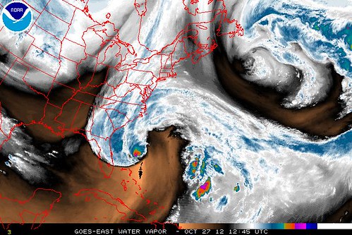
Hurricane Sandy was briefly downgraded overnight to a tropical storm, then was re-classified as a hurricane this morning when a reconnaissance airplane found hurricane-force winds. It continues to look ugly on satellite, and might be re-downgraded to a tropical storm later today. Again, none of this matters. This temporary weakening trend was and is expected. It doesn’t (yet) suggest that the models are wrong, or that Sandy will underperform its forecasts (as Irene and Isaac did). That might happen — there’s always the possibility that models are wrong — but we have NO EVIDENCE to suggest that yet. As Bryan Norcross wrote yesterday, “Either every model is wrong or this is serious as a heart attack.”
Please read Norcross’s whole excellent post from last night, and understand that — distracting noise about downgrades and “hybridization” aside — Sandy remains a deadly serious threat, including to hyper-vulnerable New York City.
Beyond that reminder, there isn’t too much new to report this morning. There continues to be some disagreement among meteorologists about precisely when, and how, this storm will fully transition from tropical to extratropical — but that’s a bit of a sideshow for the public, since Sandy will be a very serious storm regardless of whether it has a warm, cold, or hybrid core at landfall. As for its target, the European model still favors landfall in the Delaware Bay vicinity, while most other models are further north along the New Jersey coast, in a very dangerous position for a potentially catastrophic New York City storm surge. It’s too early to say who’s right. What’s clear is that some portion of the Megalopolis will take a very significant hit.
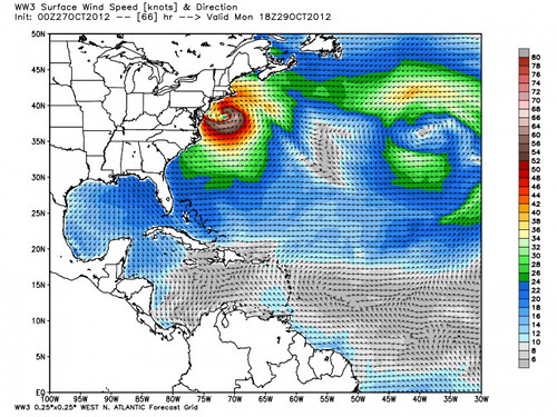
Everyone from the Beltway north to New England needs to prepare — and do so TODAY. (Preparedness links can be found at the bottom of this post.) Don’t wait until tomorrow to prepare. Sandy’s forecast track is speeding up. Landfall is now expected to occur Monday night, not Tuesday, and bad weather will begin well in advance of the center. If you’re in the potential strike zone, PREPARE NOW.
By the way, you’ll note I mentioned New England. I would specifically include interior New England, not just the shoreline. You won’t hear a lot of talk about this in the media, but from an analysis by Dr. Ryan Maue (link is on a premium section of his WeatherBell site; free trial here) has me concerned about the possibility of higher-than-forecast winds and wind gusts north and east of the center. I’ll try to do a post later tonight explaining why that is so (though the meteorological mechanics of it, involving “tropopause folds” and “potential vorticity towers,” are a bit above my pay grade), but for now, suffice it to say, folks in New England — and throughout the area, for that matter — should make sure they secure any potential flying debris to the extent possible, and prepare for lengthy power outages, because I think interior wind may take a real toll there.
I am taking my older daughters to a football game in Laramie, Wyoming today (we live in Denver), so I won’t be in front of my computer for the rest of the day. I’ll have my iPhone and will undoubtedly update my Twitter account (@brendanloy) periodically, and I’ll try to post a quick update on this blog if major developments occur. But I would also highly recommend the following sources to stay abreast of developments:
(List after the jump.)
• Amy Sweezey’s “Wx Tweeps” Twitter list. During big storms, I switch my phone’s Twitter app from following my regular Timeline to following that list, and I get all the information I could possibly need. The list is that good. It includes pretty much every major weather account you need to follow (though, alas, not my account!).
• The Washington Post‘s Capital Weather Gang, which has been invaluable throughout Sandy and has good information for the whole region, with a particular focus on the Beltway area.
• Eric Holthaus’s @WSJweather Twitter account, with a lot of information about the NYC threat (a rare example of a must-follow account not on Sweezey’s list).
• Mike Smith’s Meteorological Musings
• TWC Hurricane Specialist Bryan Norcross’s Blog
• Weather Underground Founder Dr. Jeff Masters’s Blog
• Connecticut meteorologist Geoff Fox’s blog
• And, of course, last but not least, the National Hurricane Center, for the latest official information on Sandy.
Like I said, I’ll keep updating my Twitter account periodically throughout the day, and will try to update this blog in the event of any major developments. Otherwise, I’ll be back with another update later tonight… probably after the Notre Dame-Oklahoma game. (It’s a big football day in the Loy family. Boise-Wyoming in person, then ND-OU on radio/TV.)
I’ll leave you with my oldest daughter’s Hurricane Sandy tracking chart as of last night:
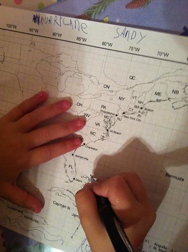
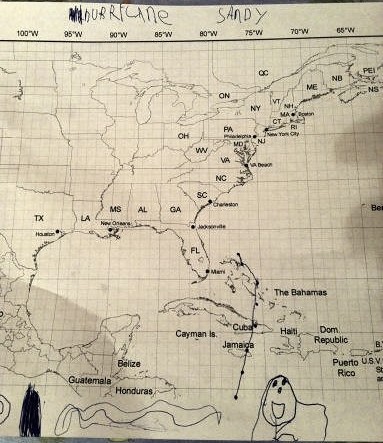
As one of my friends on Twitter said, “It’s like a baseball nerd teaching their kid how to keep score during a game.” Heh. Yup. Weather Nerd in training!


Join the conversation as a VIP Member