
[NOTE: For my latest updates on Sandy, follow me on Twitter.]
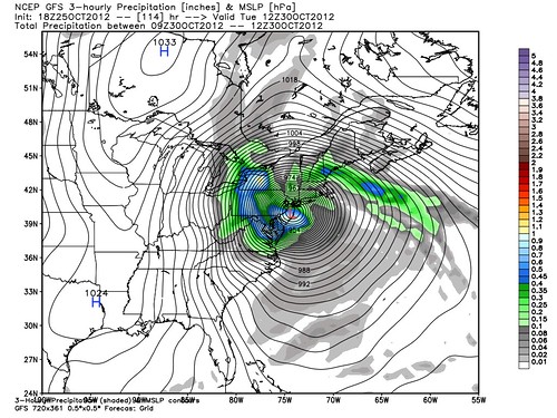
Above: the latest GFS model forecast for Tuesday morning, hot off the presses (or rather the Twitters). That track and intensity — a Category 4-like 940 mb, albeit in a spread-out hybrid storm such that the winds would not be Cat. 4 level (and the model may be overdoing the intensity a bit anyway) — would be bad, bad, bad news for New York City and environs, if it were to occur. But remember, this is just one model run, the forecast is very uncertain, the computer models are still shifting around a lot, and Hurricane Sandy is, in any event, huge and growing — so it will impact a very wide area. Everyone from North Carolina to Maine is potentially at risk, and needs to watch this closely.
The Washington Post‘s Capital Weather Gang has another excellent roundup of information about Sandy. Perhaps the most important takeaway is this quote from Charlotte meteorologist Brad Panovich:
It’s very rare to see a strong tropical system merge with such a strong winter-like trough of low pressure. Throw in a full moon and the potential is there for a significant storm. This system is 1 part Hurricane, 1 part Nor’easter and 1 part Blizzard potentially. Impacts of all 3 types of storms are possible depending on location.
For those on the coast don’t let the Category of the storm or whether it’s “just” a Nor’easter dictate your response. Your personal memories of previous storms are no use in this unique situation.
One of the biggest mistakes people make when a storm threatens is to assume “I’ll be fine because I was fine in [prior storm X].” If this storm has you in its sights, don’t make that mistake. Prepare in the manner that’s prudent based on the forecasts and warnings for this storm, not some earlier storm. Every storm is unique — and this one has uniquely damaging potential. It could be worse than the so-called “Perfect Storm,” writes Will Komaromi, a University of Miami researcher:
The odds of a potentially historic meteorological event occurring in the vicinity of the northeastern United States next week are increasing. The players on the field are as follows: Hurricane Sandy traveling northward along the east coast of the U.S., a warmer-than-average Gulf Stream, a very deep upper-level trough over the central U.S. currently bringing snow to Colorado, and unusually strong high-latitude blocking … An increasing number of model forecasts are now “phasing” Sandy with the mid-latitude trough, and given the amount of upper-level jet energy available in this setup, this could become a particularly powerful phasing event.
Something similar happened in late October through early November 1991. It was known as “the Perfect Storm”, resulting in 13 fatalities and causing > $200 million in damages to the northeastern U.S. and fishing and shipping interests. In the Perfect Storm, northward-moving Hurricane Grace phased with a mid-latitude trough, similar to the one over the Central U.S. today. Normally a hurricane weakens as it moves northward, as it encounters an increasingly unfavorable environment. This means greater wind shear, drier air, and lower sea surface temperatures. However, with phasing events, the tropical system merges with the mid-latitude system in such a way that baroclinic instability (arising from sharp air temperature/density gradients) and extremely divergent air at the upper-levels more than compensates for a decreasingly favorable environment for tropical systems. The Perfect Storm deepened to 972 mb, and was at its strongest while out over the open ocean (but still whipping the coast with strong winds and heavy surf). …
Most of the models now indicate even stronger jet dynamics will occur next week than occurred during for the Perfect Storm, and that today’s storm could potentially deepen to well below 960 mb or even below 950 mb. The fact that the Gulf Stream is anomalously warm for this time of year means that Sandy will weaken less as a tropical system than it otherwise would have prior to the phase. Also, a very strong blocking scenario (very negative NAO) has developed over the north Atlantic means that the cyclone will be very slow moving, and is likely to retrograde westward into the northeastern U.S. rather than continue out to sea like most recurving extratropical cyclones do. While it is too early to pin-down exact impacts from the system at this time, it is likely that portions of the coastal Northeast will experience a damaging storm surge, significant beach erosion, and a prolonged severe wind and heavy rain event. Meanwhile, interior regions of western Pennsylvania into Ohio may simultaneously be experiencing heavy snowfall. Stay tuned!
By the way, about that “very deep upper-level trough over the central U.S. currently bringing snow to Colorado” … it so happens I live in Colorado, and here’s what it looked like this morning, along the route from my house to my middle daughter’s preschool:

Apologies for the Obama sign, fair PJM readers. :) There aren’t very many Romney signs in this deep-blue city. Another shot, with no political signs, after the jump…
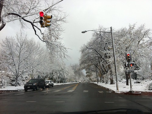
It was a picturesque overnight snowfall, coating the trees and lawns and rooftops without causing much disruption to the morning commute. Alas, the East Coast won’t be so lucky. That same trough, coupled with Sandy, is going to be very disruptive. Take it away, Angela Fritz, filling in for Dr. Jeff Masters:
Sandy’s appearance on satellite is a bit ragged this afternoon as it approaches very high wind shear (40-50 knots). The hurricane is obviously already undergoing structural changes this afternoon, caused in part by an upper level low over western Cuba. This low is prohibiting Sandy’s outflow on the west side, and as a result, the storm appears asymmetrical with a large area of outflow and circulation to the north, and only a tail of circulation on the southeast of the hurricane. Visually, Sandy is a huge storm. Based on clouds alone, Sandy stretches from Jacksonville, Florida, east to Bermuda, and south to the southern Caribbean Sea. Sandy’s radius of outer closed isobar is 350 miles, though tropical storm-force winds only extend around 200 miles from the center. …
As Sandy moves north, it will grow larger and the hurricane’s energy will spread out even more, which will lead to a slight decrease in maximum wind speed. Models agree on this steady decrease in intensity over the next few days, though beyond that, the intensity forecast is still in question since Sandy could begin to gain non-tropical energy as it transitions into a non-tropical storm. The track through Saturday evening remains well understood by the models: Sandy will move north with a slight turn to the west before being yanked north-northeast again by the approaching mid-latitude trough. It’s at this point in the forecast that the models diverge, though all but the HWRF are forecasting the unfortunate turn back to the west and into the Northeast U.S. Furthest south along the East Coast is the ECMWF, which forecasts a turn into Maryland/North Carolina on Monday. The GFS forecast is a bit further north than the ECMWF, pushing Sandy onshore near Long Island late Tuesday night. However, this represents a large shift south from earlier GFS runs, and puts the Mid-Atlantic into play more than it was in earlier forecasts. [NOTE: The GFS has now shifted further, to a northern New Jersey landfall, as shown at the top of this post.] The forecast from the National Hurricane Center appears to be a compromise between the ECMWF and the GFS. The Center is forecasting Sandy to approach the New Jersey coast on Tuesday afternoon.
There are many questions surrounding this hurricane and its forecast, but I find it important to convey that Sandy’s impacts will be widespread, no matter the location of “landfall.” Risk to the Mid-Atlantic seems higher this afternoon, and as Jeff noted in his morning blog, Sandy will be a very large and possibly non-tropical storm as it approaches the coast, with gale-force winds extending up to 300 miles from its center. This increases the probability of storm surge extending far from the center of the storm, which, combined with the timing of a full moon tide, is a big concern, along with freshwater and river flooding from heavy, extended periods of rain.
I’d again urge you to read the whole Capital Weather Gang post, which in turn contains links to many other sources that are also worth reading.


Join the conversation as a VIP Member