
[First, a PSA: check the blog homepage and follow me on Twitter for the latest all weekend.]
Friday was the day Tropical Storm Isaac finally got its act together. Leaving inner core dysfunction largely in its rearview mirror, Isaac has spun up to a 70 mph tropical storm, just one notch below hurricane strength, as it nears Haiti. It may yet become a hurricane in the final hours before landfall there.
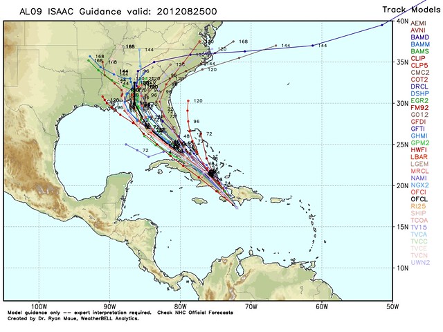
Land interaction with Haiti and Cuba should halt intensification for the next 24 hours or so, but after that, it looks increasingly likely that Isaac will have ample time over the Gulf of Mexico to strengthen into a hurricane, and perhaps a major hurricane, before striking the United States. The National Hurricane Center isn’t presently forecasting major hurricane status — they’re calling for U.S. landfall at 90 mph, a high Category 1 — but Dr. Ryan Maue calls that a “veryyyyyyy conservative intensity forecast,” and the closely watched 00z GFS computer model shows a 120 mph hurricane at landfall Tuesday evening.
The reason for the increased likelihood of significant strengthening is because the computer model consensus has shifted to the left since this morning, decreasing the likelihood that Isaac will hug Florida’s West Coast, which would have prevented intensification for a time. Instead, after an expected close encounter with the southern tip of the Florida Peninsula, and perhaps a direct hit the Keys (probably as a Tropical Storm or low-end Category 1 hurricane), Isaac appears increasingly likely to spend a good deal of time over open water en route to an eventual landfall in Alabama or the Florida Panhandle.
Here’s the latest computer model “spaghetti” chart from Weather Bell Models, and the latest official forecast track from the National Hurricane Center:
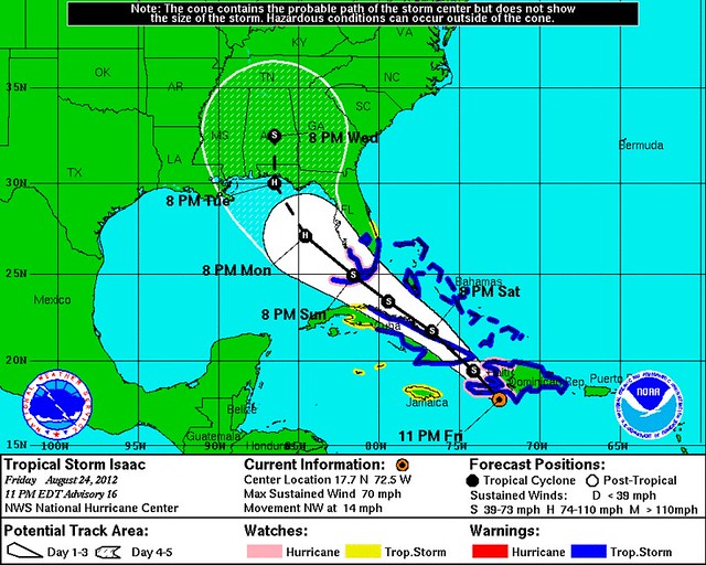
You’ll note Tropical Storm Warnings and Hurricane Watches are up for portions of Florida. Tampa isn’t in that zone yet, but I’d expect tropical storm advisories to be posted sometime tomorrow. Although a direct hit isn’t expected, and indeed looks even less likely than it did 12-18 hours ago, tropical storm force winds are expected to impact Tampa, where the Republican National Convention is supposed to start Monday.
Landfall, though, is expected to be somewhere along the northeast Gulf coast, well north of the RNC. For instance, keeping in mind that it’s just one “run” of one computer model, and very much subject to change, here’s what the 00z GFS model forecast is showing for Tuesday at 5:00 PM Eastern:
That’d be a pretty intense — and intensifying — storm when it hits the Panhandle. (Intensifying hurricanes tend to be more damaging that weakening or steady-state storms with the same listed maximum sustained wind speed, because intensifying storms generally have higher gusts relative to their sustained surface winds.) Of course, as the NHC reminds us in its 11pm discussion, “IT IS IMPORTANT NOT TO FOCUS ON THE EXACT TRACK DUE TO THE UNCERTAINTIES IN THE FORECAST AND THE FACT THAT ISAAC HAS A LARGE AREA OF TROPICAL-STORM-FORCE WINDS ASSOCIATED WITH IT.” That goes doubly for the exact track of an individual model run, and triply for the model’s intensity forecast. Everyone from Biloxi to Tallahassee, at least, should be preparing for a possible Tuesday strike from Isaac.
The Weather Channel’s Dr. Stu Ostro, newly blogging at the now TWC-owned Weather Underground, explains the forecast succinctly:
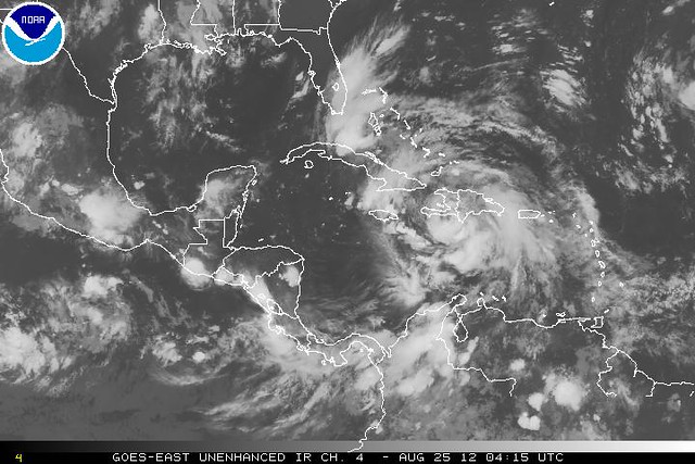
Isaac…is making a decisive move more toward the northwest rather than west as it had been going. That, along with a steering feature evident on satellite imagery — a trough of low pressure dipping south over the eastern Gulf of Mexico — suggests that Isaac will move readily across Cuba to the Florida Straits and, with its large size and effects extending well in advance of the center, bring them into South Florida and the Keys beginning as early as late tomorrow night and Sunday morning.
After Isaac enters the Gulf, the model (“European”) which is normally thought to be the most accurate but had an epic FAIL with Debby has been erratic with its Isaac track forecast, shifting between a central and eastern Gulf Coast destination, whereas our other main model has been steadier and on the east side, into the Florida Panhandle and quickly. Thus there are still model differences, but regardless, the bottom line is that a tropical storm or hurricane is expected to hit the eastern or central Gulf Coast during the early-middle part of next week, and residents and visitors should stay abreast of the latest forecasts and information.
Effects from Isaac in the U.S. will include wind, storm surge, high surf, and rainfall, and will be experienced for a longer time by people in the path of Isaac than would be the case with a storm which is tiny in size and dissipates quickly upon making landfall, such as was the case with Beryl when it hit Florida in May. Details of impacts in any given location will depend on the exact track, intensity, and structure of the storm at that time. Effects won’t be confined to the coast, and Isaac will also be capable of spawning tornadoes.
I am beginning to suspect that, even if Tampa is largely bypassed, the Republican Party will end up needing to compress its convention, or at least the “made for TV” portion thereof, into Wednesday and Thursday. This is largely based on a “Gustav precedent,” when they cancelled Day 1 of a convention in Minnesota because of the perceived optics of throwing a big party while a hurricane was hitting the Gulf. Imagine those same optics if the hurricane was just a couple hundred miles, or less, away. So yeah, I think the GOP convention will end up basically starting Wednesday, after Isaac is inland. But I’m just speculating that; I don’t know.
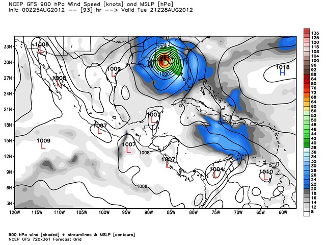
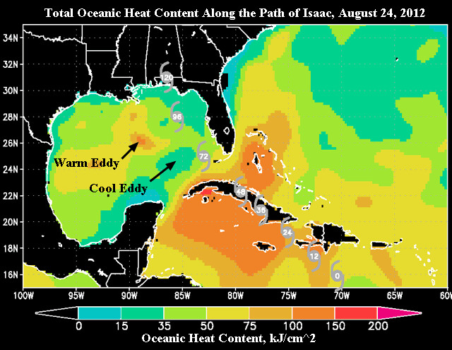
Back to the intensity forecast for a moment: the good news, as Dr. Jeff Masters noted earlier today, is that the Gulf waters aren’t as conducive for rapid intensification as we’ve seen in years past. Here’s a map to demonstrate this:
Dr. Masters explains:
For tropical cyclones in favorable environmental conditions for intensification (i.e., vertical wind shear less than 15 kt, mid-level relative humidity >50 %, and warm SSTs [i.e., >28.5C]) and with intensities less than 80kt, values of ocean heat content greater than 50 kJ/cm^2 (yellow and warmer colors) have been shown to promote greater rates of intensity change. Isaac will be in such a region when it is over water between its current location and the Florida Keys. Once Isaac goes beyond the Keys, total ocean heat content will fall to levels not as conducive for rapid intensification. …
While the surface waters in the Gulf of Mexico are very warm, near 30 – 31°C, the total heat content of these waters is unusually low for this time of year. We got lucky with the Gulf of Mexico Loop Current this summer, as it did not shed a big warm eddy during the height of hurricane season, like happened in 2005 (I discuss this in my Gulf of Mexico Loop Current Tutorial). Without the type of super-high heat energy we had in 2005 in the Gulf of Mexico, I doubt we can get a Category 5 hurricane in the Gulf in 2012.
And thank goodness for that. The possibility of Isaac becoming a Category 2 or 3 hurricane, though, remains very much alive. We shall see. A big factor will be, not how much the wind speed per se weakens over Haiti and Cuba, but how much of the storm’s newly developed inner core structure is maintained over the islands. If the mountains of Cuba just basically rip the storm’s core apart, it will take longer for Isaac regain its strength, and intensificaiton to a major hurricane is unlikely. So, root for those mountains to do their thing, I guess.
Get updates at Weather Nerd.


Join the conversation as a VIP Member