
It’s been a rough couple of days for the Republican Party, what with Missouri U.S. Senate candidate Todd Akin’s absurd comments about “legitimate rape” dominating the news and putting GOP hopes of a Senate majority in jeopardy. Now a weather development may pile on the party’s misfortune. While Akin’s damaging idiocy might feel like a force of nature, the GOP may need to start watching a real force of nature: a developing tropical cyclone that could, potentially, threaten to disrupt the Republican National Convention in Tampa next week.
“Invest 94L,” as it’s presently known, has been a focus of hurricane trackers’ attention for several days now, and tonight it’s showing new signs of organization. It appears highly likely to become a tropical depression on Tuesday, and to earn the name Tropical Storm Isaac not long after that.
In its 2:00 AM Atlantic Tropical Weather Outlook, the National Hurricane Center declared that 94L is almost certain to become a depression soon:
A WELL-DEFINED LOW PRESSURE IS LOCATED ABOUT 725 MILES EAST OF THE LESSER ANTILLES. THUNDERSTORM ACTIVITY HAS INCREASED AND BECOME BETTER ORGANIZED NEAR THE CENTER DURING THE PAST SEVERAL HOURS. IF THIS RECENT DEVELOPMENT TREND CONTINUES…THEN A TROPICAL DEPRESSION COULD FORM LATER THIS MORNING. THIS SYSTEM HAS A HIGH CHANCE…NEAR 100 PERCENT…OF BECOMING A TROPICAL CYCLONE DURING THE NEXT 48 HOURS AS IT MOVES WESTWARD AT 20 TO 25 MPH. THIS LARGE DISTURBANCE COULD REACH THE LESSER ANTILLES BY WEDNESDAY…AND INTERESTS IN THAT AREA SHOULD CLOSELY MONITOR THE PROGRESS OF THIS SYSTEM SINCE TROPICAL STORM WATCHES COULD SOON BE REQUIRED FOR PORTIONS OF THOSE ISLANDS.
It is very, very, very early to speculate in any degree of detail about this proto-storm’s possible long-term future track or intensity. It’s a good 5 to 6 days away from any possible mainland U.S. impact, and computer model tracks are subject to huge errors at the 5-6 day time frame — even more so when the storm being modeled doesn’t even fully exist yet. Computer model intensity forecasts this far out, and this early in a cyclone’s life, border on useless.
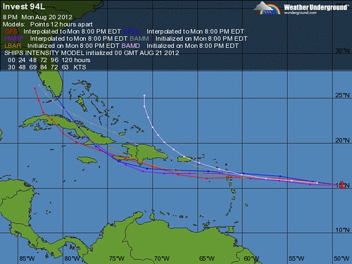
That said, this Weather Underground map of model tracks — imprecise and subject to massive correction tough it is — has to be causing a little bit of heartburn at the Republican National Committee, don’t you think?
Four years ago, the GOP had to struggle with how to set the proper tone for its convention while Hurricane Gustav was impacting the Gulf coast. But the convention was far away in Minnesota. This time, conceivably — and I emphasize again that it’s very, very early, and anyone from Mexico to Maine could be this storm’s eventual landfall target — conceivably, the party might have to deal with some more direct effects of hurricane season.
The convention is set to begin Monday, August 27. That’s also roughly when Isaac might be showing up, perhaps in the vicinity. Stay tuned, as they say.
P.S. Here’s what Dr. Jeff Masters had to say earlier Monday about 94L:
None of the reliable models predict that 94L will reach hurricane strength over the next five days, and it is unlikely that 94L will be able to organize quickly enough to become anything stronger than a 60 mph tropical storm before reaching the Lesser Antilles, given the storm’s current struggles with dry air, and the lack of model support for intensification. However, once 94L enters the Eastern Caribbean, wind shear will be low, oceanic heat content high, and the storm should have had enough time to moisten the atmosphere to allow steady strengthening to occur. The main factor that might prevent intensification into a hurricane late this week would be a close pass by the island of Hispaniola. Our top models for long-range 4 – 5 days forecasts all show a path for 94L very close to the island. …
A trough of low pressure capable of pulling 94L to the north enters Western Canada Thursday night, and the exact timing and amplitude of this trough will determine the ultimate landfall location of 94L. The long range 7 – 14 day runs of the GFS model over the past three day have all predicted an eventual landfall for 94L in the U.S., though these long-range runs are notoriously unreliable. The predicted landfall locations have ranged from New England to Texas–which isn’t much help. The past three runs beginning on Sunday afternoon have all taken 94L over Florida during the August 27 – 29 time frame, which I’m sure is making organizers of the Republican National Convention uncomfortable, since the convention is in Tampa August 27 – 30. However, 94L could miss Florida completely, as the average error in model forecasts going out 7 days is in excess of 500 miles. We can’t rule out a North Carolina landfall, but the pattern we’ve seen so far this year is for landfalls in Mexico’s Yucatan Peninsula, so a more southwards path for 94L into the Yucatan is definitely a possibility. Also, we have that huge drought region in the Midwest, which tends to create its own high pressure bubble, which reduces the odds of storms making the turn and hitting the Central or Western Gulf Coast. If 94L makes it to the Western Caribbean, I see the two most likely options as a landfall in Mexico’s Yucatan Peninsula (and then westwards into Mexico south of the Texas border), or recurvature into the Florida Gulf Coast.
Dr. Masters also wrote a week ago, in more general terms, about the possible risk to the convention in Tampa.


Join the conversation as a VIP Member