
In a post that went up a couple hours after mine, Dr. Jeff Masters summarizes the forecast thinking regarding Tropical Storm Nate:
Given the favorable environment, in addition to a very warm pocket of sea surface waters in the central Gulf of Mexico, we expect that Nate will intensify modestly over the next few days. The National Hurricane Center forecasts that Nate will become the third hurricane of the season by Friday. The HWRF and ECMWF agree with this forecast–both of these models bring Nate to a category 2 hurricane by Saturday. The IVCN/ICON consensus models that the Hurricane Center relies on are more conservative, peaking at category 1 intensity. Nate’s maximum potential intensity is heavily dependent on its track, which, according to the weather models, has been up in the air for the past few of days. Until this afternoon’s run, the ECMWF has held true to its forecast that Nate will track north and make landfall anywhere from Louisiana to Florida. This afternoon, it backed off of that solution and is now forecasting a northern Mexico landfall. The GFS has consistently forecasted a track that lingers in the Bay of Campeche for a few days before ultimately making dive to the west into Mexico. Over the past few days the Canadian CMC model has been reluctant to develop Nate at all, but today is forecasting the system to track north into the Southeast U.S. states. Now that there is Hurricane Hunter data to ingest (as well as confirmed 45 mph surface wind speeds), we expect the models will come into better agreement on both track and intensity for Tropical Storm Nate.
The National Hurricane Center’s 11pm EDT discussion emphasizes the gradualness of the intensification:
NATE IS FORECAST TO REMAIN IN AN AREA OF LIGHT VERTICAL WIND SHEAR FOR THE NEXT 36-48 HOURS…AND THE INTENSITY GUIDANCE RESPONDS TO THIS LOW SHEAR AND THE WARM UNDERLYING WATERS BY FORECASTING STRENGTHENING. HOWEVER…THERE IS ABUNDANT DRY AIR TO THE NORTHWEST OF NATE WHICH COULD SLOW THE RATE OF STRENGTHENING IF THE STORM INGESTS IT…AND THE CURRENT STORM STRUCTURE IS NOT FAVORABLE FOR RAPID STRENGTHENING. BASED ON THIS…THE INTENSITY FORECAST SHOWS GRADUAL STRENGTHENING INTO A HURRICANE DURING THAT TIME.
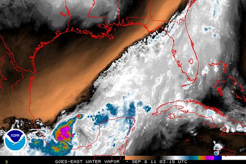
You can see the “abundant dry air” in the water vapor image at the top of this post. It’s the orange part.
After 48 hours, there is “uncertainty” and divergence among the models about how strong Nate will get. One reason the intensity depends in part on the track is that the waters have more tropical cyclone heat potential a bit further north. Also, the longer Nate stays in one place, the more it will weaken the water directly underneath it through “upwelling” — its winds and surf bringing up colder water from just beneath the surface.
Anyway, again, with regard to Nate’s track, the general forecast thinking is a path toward the Mexican coast, but there is considerable uncertainty, and the Canadian model taking Nate toward the U.S. Gulf Coast remains, albeit as an outlier. Here’s a look, courtesy of Ryan Maue’s site, at what two models are forecasting in 4 1/2 days’ time: first the HWRF, then the Canadian model.
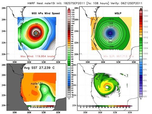
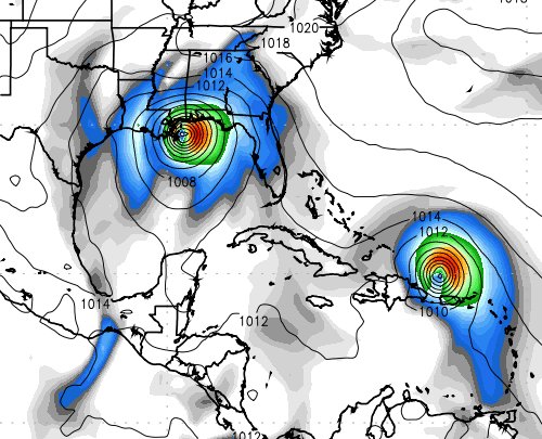
That’s Nate at left, Maria at right in the bottom (Canadian) image.
Updates tomorrow (Thursday) will likely be limited, but you can get the latest from my Twitter feed, and also track down the relevant data yourself, if you so desire, using the links from my “day in the life” post.


Join the conversation as a VIP Member