
[NOTE: For the very latest information, check my Twitter feed.]
* * * * *
For a variety of practical reasons, I’ve had to focus my Irene-related energies exclusively on Twitter all day, and haven’t posted an update here in more than 12 hours. But, truth be told, I don’t have much new to say about the storm, meteorologically at least, that I didn’t say this morning.
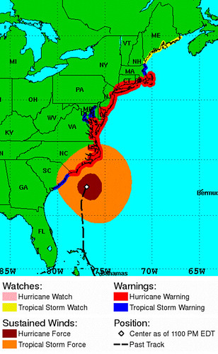 Irene is continuing to move north (now slightly NNE, as expected) on the predicted track, with the computer models now tightly clustered around a path that, after walloping North Carolina’s Outer Banks, should take the storm’s center right up the coast, directly along the shore of the Delmarva and New Jersey, and then into (most likely) west or central Long Island. As for the storm’s intensity, it’s now down to 100 mph, a minimal Category 2, and re-strengthening still looks unlikely. After hitting North Carolina tomorrow morning at roughly its current intensity, Irene is still expected to start weakening more steadily, and hit the Mid-Atlantic and New York/New England as a Category 1 or strong tropical storm.
Really, at this point we’re in the stage of waiting and watching what the actual impacts will be. We can be fairly confident that the flooding rains will be severe, and that power outages will be widespread — but that otherwise, the winds won’t cause much severe damage beyond North Carolina (although the duration of sustained tropical-storm force winds will create some problems). The big question is how bad the storm surge will prove to be. (Speaking of which, you can watch various NOAA tidal gauges in Irene-affected regions here.)
It’s expected that the sheer size of Irene, coupled with astronomical high tides, coupled with the storm’s slow movement (meaning that, at any given location, winds of at least tropical-storm force may extend through an entire tide cycle or two), will result in a greater surge than you’d expect given what Irene’s wind speed will be. This expected surge is seen as a major threat to various coastal locations, including low-lying areas in New York City, as well as to the NYC subway system, which is why New York ordered an unprecedented mandatory evacuation of “Zone A” and all of the Rockaways, and announced it would shut down its entire transit system starting Saturday at noon. (It also led to New Jersey governor Chris Christie’s epic rant at dawdling beachgoers, in the YouTube clip at the top of this post.)
But will the surge predictions be borne out? I remember well the predictions of a catastrophic, higher-than-the-winds-would-indicate storm surge with Hurricane Ike in 2008, and those predictions weren’t borne out by the reality (although the surge was plenty bad). Will the same thing happen with Irene, or will the surge meet (or exceed) forecasters’ expectations? I just don’t know. I certainly continue to strongly urge everyone to assume the predictions are true, and prepare for the worst. But I’m really very curious to see what will happen. Will the subways flood? Will the airports and the Rockaways be submerged? Will much of Hoboken be underwater? We’ll find out soon!
In the mean time, some smart decisions were made today. Mayor Bloomberg proved he’s not an idiot — well, at least not on this issue — and that he’s no Ray Nagin (who, incidentally, is apparently MSNBC’s new disaster preparedness expert), by ordering the mandatory evacuation around midday today, instead of tomorrow morning as he’d foolishly planned. Also, the NFL preseason game between the Jets and Giants, which had been absurdly scheduled to go forward tomorrow afternoon amid evacuations and transit shutdowns, has been rightly postponed to Monday evening. Sanity prevails over indefensible idiocy. Hooray!
Of course, the biggest decisions are the ones to be made in the next 12-18 hours by individual people in the path of this storm, deciding whether to take it seriously and what precautions to take. Bottom line: take it seriously. If you’re in an evacuation zone, leave. If you’re not, hunker down and make sure you have everything you need for a potentially long and unpleasant aftermath. Maybe some of the evacuations will prove, with the benefit of hindsight, to have been unnecessary, and maybe some of the hurricane-kit items won’t be needed, but it’s far better to be safe than sorry, especially when dealing with something as difficult to predict as a hurricane. So, as I keep saying on Twitter, take Irene seriously and #PREPARE.
And remember that, if the worst doesn’t happen, that doesn’t mean the storm was “overhyped.” It means that, of the various plausible scenarios that presented themselves to forecasters, we ended up experiencing one of the numerous “less bad” scenarios. Worst-cases are always unlikely, and most hurricane “alarms” end up being, at least in part, “false” alarms. That’s just the nature of the beast, as I wrote in my “misconceptions” post. It doesn’t mean we shouldn’t prepare for the worst — every time. Hope for the best, prepare for the worst. There’s just no other choice. That’s exactly what people should keep doing now.
Oh, and get the Hell off the beach.


Join the conversation as a VIP Member